
Instrument Support Level 3
SgurrEnergy, Galion 4000
ncas-lidar-wind-profiler-1
mean-winds-profile
£200,000
82 cm x 53 cm x 77 cm. 85 kg
112 cm x 70 cm x 120 cm. 200 kg
£50
Calendar
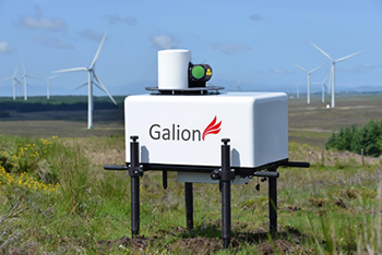
Lidar Wind Profiler
Galion 4000 Lidar is a laser-based wind profiler device, developed by SgurrEnergy to measure wind speed and capture directional data.
With its unique all-sky scanning capability and up to 4km range, Galion is a mature remote sensing technology that is successfully used for wind mapping applications worldwide.
Features of Galion Lidar
- Pulsed laser device for wind speed and direction measurement
- High-resolution data capture
- Up to 4km range
- Remote access to real data
- All-sky scanning steerable beam
- Environmentally tested from -15°C to +35°C
- Independently validated by Risø DTU, Deutsche Wind Guard, Fraunhofer IWES and DNV Kema
Galion’s scanning options
- A variety of scan options are available and Galion can conduct 3D scans including:
- Vertical cross-section scan
- VAD scan
- Arc scan
A fundamental characteristic of all Doppler Lidars, is the ability to measure the line of sight Doppler component along the out-going beam. Normally, a series of individual beams or rays must be acquired in order to sample the wind field at sufficiently different angles to allow the wind speed and direction to be calculated. An anemometer will sample the wind over a very small volume – like a metre cubed for example, whereas the Lidar will generally give an averaged result taken over a much larger area (hundreds of metres). These different measurement techniques can often produce a difference between wind data as measured with a point sensor like an anemometer, and a volume sampling device like a Lidar or a Radar wind profiler. To some extent, the results will be very similar as long as the wind is behaving in a uniform manner so that the Lidar and point sensor both experience the same conditions.
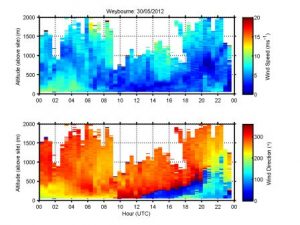
The Lidars are often used in a PPI scanning arrangement for wind data measurement – which essentially involves scanning the beam through a full 360° at a selection of evenly separated azimuth angles at a fixed elevation. The data set can then be processed to give wind speed and direction for each discreet range gate. The result is a wind profile that applies directly over the device and represents an average over the conical shape that has been sampled (increasing volume with height). Another method is to scan a sector at a fixed and usually, low elevation. Typically, a sector of at least 90° in azimuth (sampled with 10° increments for example) should be used in order to provide sufficient data for sector scanning analysis. The data below was captured using this technique. A further technique which will result in a much smaller volume measurement – and more comparable to a point sensor, is the dual or triple Doppler measurement. In this case, more than one Lidar is used to sample the same small area of atmosphere at the same as another one or two Lidars. The Lidars must all be sufficiently separated in distance in order to provide a sufficient amount of observation angle difference. In this way, each Lidar will measure a different component to the others, and knowing the positions of the Lidars will allow the wind data to be calculated at each point where the beams intersect.
While every effort has been made by the manufacturer to provide accurate and calibrated data products, the Wood Group does not guarantee the calibration of the data in absolute terms.
Wherever and whenever possible instrument comparisons take place where, for example, wind profiles derived from a range of measurement sources are compared. It is the results of such comparison exercises together with continual monitoring both during and after a deployment, and the system diagnostics that allow the Facility to determine if the system is operating optimally or requires manufacturer servicing and intervention.
Costs
- Instrument Insurance
- This system must be insured by the user for £200K and covers loss, theft or damage to the instrument: damage is that over and above general wear and tear.
- The system has been designed to be rugged and autonomous. Even so, the end-user must respect the fact that the system is a precision optical instrument that must be treated with great care.
- The user is responsible for the instrument from the time it leaves the AMF to the time it is returned and signed off as in an acceptable operating condition by the IS: this will be done as soon as is possible on its return.
- Public Liability Insurance
- The AMOF is not liable for any damage or injury arising from the deployment or operation of this instrument when unattended by the IS.
- Shipping Expenses
- The user is liable for all costs arising from the shipping of the instrument both to and from a deployment.
- IS T&S
- The user is responsible for coving the travel and subsistence expenses of the IS while attending the instrument.
Shipping
The system when packed ready for shipping consists of a single box:
- Dimensions:
- 112 cm x 70 cm x 120 cm.
- Weight
- 200 kg
The LiDAR should be deployed on a surface that is not liable to get excessively hot, as the cooling aggregate (air-flowed heat exchanger) is located on the underside of the base unit. Steps should be taken to minimise the heat generated underneath the LiDAR from direct sunlight – a turfed area is ideal. For cold running, a windbreak to protect the LiDAR from the prevailing wind will help.
When considering the deployment locations some thought needs to be given to potential obstructions to the beam. This will also depend very much on how the instrument is to be operated but in general, an unobstructed full-sky view is recommended.
Although requiring two people to move, the system will require securing to a surface to prevent movement due to wind impact. It should also be located on a secure site to avoid theft and vandalism.
For ease of operation, it is advised to ensure that there is network infrastructure to hang the instrument on. If a network is not available then the user will have to connect to the instrument via the local network connection using a cross-over cable.
At sites where the animal activity is likely precautions will need to be taken to prevent chewing\pecking of cables.
Eye safety: This system contains a class 1M category laser and is eye-safe for all conditions of use.
Manual handling: When in its packing case it is recommended that four people be used when lifting. Once out of the case the instrument requires two people to lift and or move it. At least one cable has to run to the instrument and so users should be aware that both the instrument and the power cable constitute a trip hazard and users should take appropriate actions to minimise this.
Electric safety: Under no circumstances should any attempt be made to open the main body of the instrument. The power supply and UPS units that are separate from the instrument can be opened if problems occur but only once they have been disconnected from both the supply and the instrument. Only appropriately qualified persons should attempt to fault find these units.
Attended operation: There is no requirement for the system to be attended during operation from a safety standpoint.
COSHH: Not applicable.
When unpacked and deployed the LiDAR has the following physical characteristics:
-
Footprint: 150 cm (L) x 100 cm (W) x 150 cm (H)
-
Weight (not including shipping case): ~80 kg
-
Power: 300W @ 240VAC
-
Operation temperature: -20°C to 40°C
Cables
- Power: The user will need to supply a 3 core power cable of appropriate length for the deployment. This needs to be terminated by a 16A 240V 3P (2P + E) connector at the instrument end.
- Signal: The user will need to supply either
- a standard cat5 ethernet cable of appropriate length for the deployment
- a cat5 cross-over ethernet cable of appropriate length for the deployment
Field Data
- The instrument produces a range of out files and all are text format.
- The user can download (but not delete) this data from the instrument but it should be noted that this data will not have been quality controlled.
Archive data
- Data is provided in NetCDF files following the AMOF data standard
- Files contain no more than 24 hours worth of data.
- Instrument name is
- ncas-lidar-wind-profiler-1
- The data product(s) associated with this instrument
- v1.1
- Vertical dimension uses “index”.
- For profiling instruments (not the radiosondes) the altitude variable and profile variables have dimensions of time and index
- The version should be used if the altitude variable is likely to vary over the duration of the file.
- mean-winds-profile
- v2.0
- Vertical dimension uses “altitude”.
- For profiling instruments (not the radiosondes) the altitude variable has dimensions of altitude and the profile variables have dimensions of time and altitude
- The version should be used if the altitude variable does not vary over the duration of the file.
- mean-winds-profile
- Example data file
- v1.1