Instrument Support Level 3
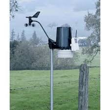
Davis Vantage Vue
Not Applicable
Calendar

Davis Automatic Weather Station
The Davis Vantage Vue meteorological suite at the Cape Verde Atmospheric Observatory (16° 51′ 49 N, 24° 52′ 02 W) provides measurements of wind speed (m/s), wind direction (16 compass points), temperature (°C), relative humidity (%), barometric pressure (mbar) and rainfall (mm) from a height of 30m.
The measurements are made on a continuous basis and are available on a minute timescale through the Centre for Environemntal Data Analysis (CEDA) archive. The data can be used as supporting data to interpret other measurements made at the CVAO or can be inputted into atmospheric models over a range of timescales.
This is a wireless weather station which runs continuously and collects data every 2.5 seconds. It is mounted on the 30m tower at the Cape Verde Atmospheric observatory. It is solar powered but with a stored energy backup. It monitors barometric pressure, rainfall, wind speed and wind direction, temperature and relative humidity.
Wind Direction: The weather station has an accuracy of plus/minus 3°. Range 360°. Reported as 16 points (22.5°) on compass rose.
Wind Speed: The anemometer records wind speeds as low as 2 mph (0.9 m/s) and as high as 150 mph (67 m/s). The accuracy plus/minus 1 ms-1 or 5%, whichever is greater. Max measurement 80 m/s (80 mph).
Temperature: The temperature sensor provides outside temperature readings from -40°C to 65°C with an accuracy plus/minus 0.5°C above -7°C, plus/minus 1°C. Relative humidity is measured from 0 to 100%. Accuracy (at 25°C) is plus/minus 3% over 0-90%, plus/minus 4% over 90-100. The sensors are contained in radiation shield for optimum accuracy.
Atmospheric Pressure: Total Accuracy plus/minus 1.0 mb at 25°C.
The rain collector reports rain rate and rain totals. It consists of a self-emptying tipping spoon, which measures rain with 0.2 mm resolution.The measurement range 0-6553mm. Accuracy plus/minus 4% or 0.2mm whichever is greater.
Data is compared regularly with the measurements made at 7.5m to ensure trends are accurate.
The sensors are either replaced or sent back to the manufacturer for recalibration every 3 years unless there are faults that occur before this date.
Field Data
- The instrument produces a range of out files and all are text format.
- The user can download (but not delete) this data from the instrument but it should be noted that this data will not have been quality controlled.
Archive Data
- Data is provided in NetCDF files following the AMOF data standard
- Files contain no more than 24hr of data.
- Instrument name is
- ncas-aws-7
- The data product(s) associated with this instrument:
- Example data file
