
Instrument Support Level 6
Radiometer Physics RPG-FMCW-DP-KW Scanning dual-polarisation, dual-frequency Ka/W-band cloud radar
Under Development
£820,000
172L x 164W x 220H (cm), weight 640 kg
Flight case (radar) W-Band 94 GHz: 115L x 135W x 105H (cm), weight 235kg Flight case (radar) Ka-Band 35 GHz: 165L x 90W x 130H (cm), weight 280kg Wooden box for the combined 94 GHz and 35 GHz scanning unit: 200L x 160W x 180H (cm), weight approx. 800kg
£70: when operating away from home base. £50: when operating at home base.
Calendar
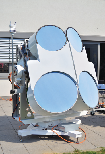
Ka/W-band Mobile Cloud Radar
AMOF will be taking delivery of a new cloud radar manufactured by RPG Radiometer Physics GmbH in August 2026, to replace the “Kepler” Metek MIRA-35 system it operated from 2015 to 2025.
The new mobile cloud radar uses a Frequency Modulated Continuous Wave (FMCW) signal and operates at both Ka-band (35 GHz) and W-band (94 GHz), and has Doppler and dual-polarisation capability. Each radar has a bi-static cassegrain antenna (700mm/500mm) with a beam width of 0.85/0.56 degrees. The radar has high sensitivity for observing clouds, and measures radial winds and depolarisation due to non-spherical targets. It has a wide range of applications including: cloud microphysics and dynamics, and precipitation processes.
A container platform will be procured for mounting the radar as well as additional remote sensing instruments. It is anticipated this will be in operation from the end of 2027.
| Frequency | 35 GHz | 94 GHz |
| Beamwidth | 0.85°±0.05° | 0.56°±0.03° |
| Antenna Type and Diameter | Bi-static Cassegrain 700mm | Bi-static Cassegrain 500mm |
| Antenna Gain | 47.5±0.5 | 50.1±0.5 dB |
| Transmitter power | 20W | 2W |
| Typical operating range | 100 m to 10 km typical, 50 m minimum,18 km maximum | |
| Scanning range | Full sky scanning capability with maximum angular velocity of 5 °/sec in azimuth and elevation | |
| Typical resolution | 15-30 m | |
| Sensitivity | -45 dBz to +30 dBz (at 5 km height / 30 m resolution) | -46 dBz to +20 dBz (at 5 km height / 30 m resolution) |
| Moment data | Reflectivity, Mean radial velocity, Spectrum width, Skewness, Kurtosis | |
| Polarimetric data | Differential reflectivity (ZDP), Cross-channel correlation coefficient ρhv, Differential phase shift ΦDP, Differential attenuation ADR, Propagational differential phase shift KDP, Slanted Linear depolarization ratio (SLDR), Co-cross-channel correlation coefficient in the slanted basis ρcx | |
| Spectral data | Reflectivity spectra | |
| Spectral polarimetric data | sZDR, sρhv, sΦDP, sSLDR, sρcx | |
In the UK, the radar requires an “OfW 225 non-operational innovation and research licence”. The licence has to be applied for, usually takes between 6-8 weeks to be granted and costs £50. Other countries will probably require a similar kind of licence.
The instrument scientist is responsible for monitoring the quality of the data during the deployment of the radar. The system has a number of diagnostics that allows the instrument scientist to determine if the system is operating optimally or requires manufacturer servicing and intervention. The instrument scientist will also perform standard quality control on the campaign dataset after deployment.
Consumables
Please contact the instrument scientist to discuss if any consumables are required.
Costs
- Instrument Insurance
- The user is responsible for the cost of insuring the instrument while on deployment: the insurance cost is £820K.
- The instrument scientist will generally be responsible for the instrument. However, if the user has enough experience to operate the instrument in the absence of the instrument scientist, the user will be responsible for the instrument during the deployment. In such situations as formal agreement is required for insurance purposes.
- Public Liability Insurance
- AMOF is not liable for any damage or injury arising from the deployment or operation of this instrument when unattended by the instrument scientist.
- Shipping Expenses:
- The user is liable for all costs arising from the shipping of the instrument both to and from a deployment.
- Travel and Subsistence
- The user is responsible for coving the travel and subsistence expenses of the Instrument Scientist while attending the instrument.
Shipping
Please contact the instrument scientist to discuss shipping requirements.
This radar cannot be operated without the instrument scientist, or without detailed consultation with the instrument scientist. This consultation will include detailed health and safety requirements and risk assessments. The risk assessments will be dependent on exactly how the radar is deployed, and whether or not it is in an area accessible to the public. The primary consideration is exposure to the transmissions and a radiation exposure assessment will be required to determine whether a barrier or exclusion zone is needed.
In nearly all circumstances the radar support engineer, instrument scientist and other AMOF staff will be responsible for the deployment and setup of the radar. Any user involved in the deployment must have had prior training and permission from the instrument scientist to help.
Good road access to the site, security, power and visibility are the main considerations. The instrument scientist or radar support engineer will need to carry out a site visit.
The mobile cloud radar requires flat (< 3% incline) and firm ground in a location with as few obstructions as possible to reduce the amount of ground clutter.
Electricity
- Supply Voltage: 230V
- Connection: Type Three-phase (3x16A)
- Male connector: CEE 3-pole
- Maximum consumption: 3 kW (94 GHz 500W, 35 GHz 900W, Blower 750W, Scanner 800W)
Operating conditions
- Temperature range: -10° to +35°C
- Permissible operational wind load: 90 kmph (56 mph)
Dimensions
- Weight: Combined 640kg (94 GHz 100 kg, 35 GHz 160kg, Blower unit 180kg, Scanning unit 200 kg)
- Height: 2200 mm (elevation 0°), 2316mm (elevation 45°)
- Width: 1640 mm
- Length: 1720 mm
Field Data
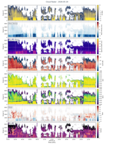
- AMOF has Python scripts that may be adapted to produce plots tailored to user needs.
Archive data
- Data is provided in CfRadial NetCDF files following the NCAS radar data standard
- Files may contain multiple sweeps (e.g. sets of RHI or PPI scans) grouped according to the particular application.
- The instrument name is
- TBD
- The data product(s) associated with this instrument:
- Level 1 – the native/raw data from the instrument software is processed to CfRadial files.
- Level 2 – QC and calibration offsets for effective reflectivity applied.