
Instrument Support Level 5
Leonardo Germany GmbH 60DX10-S X-band Radar
ncas-radar-x-band-2
£2,200,000
When installed on container 6181 (h) x 2428 (w) x 6048 (l). Weight approximately 10 tonnes. Plus two additional containers for shipping.
£70: when operating away from home base; £50: when operating at home base
Calendar
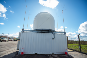
X-band Mobile Weather Radar
The moveable radar operates at X-band (9.32 GHz, 3cm) and has Doppler and dual-polarisation capability. The radar measures aerial precipitation, radial winds and polarisation parameters. It can also detect clear-air echoes at close range from insects. The system has a conventional parabolic antenna of 2.4m diameter and a beamwidth of 1 degree, operated inside a radome.
Signal analysis, data retrievals and data storage are performed by PCs contained within the container. The operational software allows the user to set up the radar for deployment and schedule the scanning sequence. The software also provides real-time data visualisation and product generation.
Frequency: 9.32 GHz
Beamwidth: 1°
Antenna diameter: 2.4 m
Antenna gain: 44.5 dB
Peak power: nominally 75 kW
Average power: ~75 W
Typical operating range: 100 – 150 km
Azimuth scanning range: 0° – 360°
Speed azimuth/elevation: 1° – 36° per second
Elevation scanning range: -5° – 185°
Measurement gate length: 75 m, 150 m or 300 m (pulse width dependent)
Number of range gates: user selectable, maximum 10000
Minimum gate spacing: 75 m
Pulse repetition frequency: 250-2500 Hz software controlled, depending on selected pulse width
Dual-PRF: 3/2, 4/3, 5/4, 7/5
Pulse width: Short pulse 0.5μs, medium pulse 1 μs, long pulse 2 μs
This instrument has a wide range of applications including: aeroecology; dynamics of convective storms and extra-tropical cyclones; cloud microphysics; deep tropical convection; boundary layer structures such as convergence lines and sea-breezes; hydrology; urban rainfall.
The moveable X-band Radar transmits pulses of electromagnetic radiation at an X-band frequency of 9.32 GHz and measures the amount of energy backscattered to the receiver.
The time delay between the transmitted and received pulses enables the range of the object to be determined.
In the case of precipitation, the magnitude of the backscattered signal is proportional to the size and number of raindrops. In the absence of precipitation, the radar is sensitive to backscattering from insects, known as clear-air echoes.
The radar also measures the radial velocity through the Doppler effect.
In addition, the radar has dual-polarisation capability; it simultaneously transmits and receives horizontally- and vertically- polarised waves.
Through this technique, the radar measures a number of additional variables that provide information on the size and shape of precipitation, target identification, attenuation, propagation effects and alternative methods for quantitative precipitation estimation.
The radar requires an “OfW 225 non-operational innovation and research licence”. The licence has to be applied for, usually takes between 6-8 weeks to be granted and costs £50. Other countries will probably require a similar kind of licence.
The instrument scientist is responsible for monitoring the quality of the data during the deployment of the radar. The system has a number of diagnostics that allows the instrument scientist to determine if the system is operating optimally or requires manufacturer servicing and intervention. The instrument scientist will also perform standard quality control on the campaign dataset after deployment.
Consumables
Please contact the instrument scientist to discuss if any consumables are required.
Costs
Instrument insurance
- The user is responsible for the cost of insuring the instrument while on deployment: the insurance cost is £2.2M.
- The instrument scientist will generally be responsible for the instrument. However, if the user has enough experience to operate the instrument in the absence of the instrument scientist, the user will be responsible for the instrument during the deployment. In such situations, a formal agreement is required for insurance purposes.
Public liability insurance
- We are not liable for any damage or injury arising from the deployment or operation of this instrument when unattended by the instrument scientist.
Shipping expenses
- The user is liable for all costs arising from the shipping of the instrument both to and from a deployment.
Travel and Subsistence
- The user is responsible for covering the travel and subsistence expenses of the Instrument Scientist while attending the instrument.
Shipping
The radar can only be transported by dismantling of the radome, antenna and pedestal and packing into its 2 storage containers. The radar container has to be carried in the ship’s loose load hold below deck. The instrument scientist should be consulted about shipping requirements in all cases.
Good road access to the site, security, power and visibility are the main considerations.
The instrument scientist or radar support engineer will need to carry out a site visit along with the crane company responsible for the offloading and assembling of the system.
The system requires a 32A 3 phase power supply.
The moveable X-band radar requires flat (<3% incline) and firm ground in a location with as few obstructions as possible to reduce the amount of ground clutter. The radar container requires anchoring to the ground, which is dependent on the operating conditions i.e. maximum windspeeds, and may require a static calculation to be carried out.
For the unloading of the containers from the transport vehicle, and for lifting and assembling of the antenna, pedestal and radome, a crane with a minimum load capacity of 10000kg (10Te) at the required lifting radius, and a crane hook height of a minimum of 15m above the centre of container surface is required.
The maximum wind speed for assembling and lifting is 5m/s.
The moveable X-band radar cannot be operated without the instrument scientist, or without detailed consultation with the instrument scientist. This consultation will include detailed health and safety requirements and risk assessments. The risk assessments will be dependent on exactly how the radar is deployed, and whether it is in an area accessible to the public or not. The primary consideration is exposure to the transmissions and a radiation exposure assessment will be required to determine whether a barrier or exclusion zone is needed.
In nearly all circumstances the radar support engineer, instrument scientist and other staff will be responsible for the deployment and setup of the radar. Any user involved in the deployment must have had prior training and permission from the instrument scientist to help.
Electrical
- Supply Voltage: 400 V
- Connection Type: 3-phase
- Male connector: CEE 5-pole 32A
- Maximum consumption: 12 kW
- Fuse of the main power distributor: 32 A
- Maximum occurring residual current: 300 mA (requires high earth leakage current RCD if one is used)
Operating conditions
- Temperature range: Operational: -30° to 40° C, non-operating -40°C – +50°C.
- Permissible operational wind load: 200km/h (124mph)
Dimensions
- Shipping containers 1 & 2: standard 20ft containers, 6060mm (l) x 2440mm (w) x 2590mm (h)
- Radar container: 2831mm (h) x 2428mm (w)
Field Data
- The radar utilises two main software applications.
- Ravis® is the maintenance and calibration software used for system diagnostics and testing, as well as real-time data visualisation.
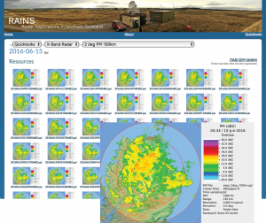
- Rainbow®5 is the scan scheduling, data visualisation, and analysis software, which provides near real-time product and image generation (“quicklooks”). These images are pngs and can be uploaded to a web catalogue for viewing and animation.
Archive data
- Data is provided in CfRadial NetCDF files following the AMOF Radar Data Standard
https://ncas-radar-data-standard.readthedocs.io/en/1.0.0/index.html
- Each file contains a single scan (e.g. RHI, VOL) or a set/volume of scans (PPI).
- The instrument name is:ncas-radar-x-band-2
- The data product(s) associated with this instrument are:
-
- Level 1 – the native/raw data from the Rainbow software is processed to CfRadial files. The Rainbow software does its own quality control to produce the raw data, and at present no further QC is undertaken.
-
- Level 2 – calibration offsets are calculated and applied to the Level 1 data. The vertical birdbath scans are analysed to calculate a bias in differential reflectivity (ZDR) and the volume scans are analysed to calculate a bias in reflectivity.